30 JANUARY 2026 14:30 - 16:00 GEOGRAPHY GRADE 12
Based on PHAKAMA RESEARCH's video on YouTube. If you like this content, support the original creators by watching, liking and subscribing to their content.
Mid-latitude cyclones form between 30° and 60° latitude along the polar front where warm and cold air masses meet, producing a low-pressure system with both cold and warm fronts.
Briefing
Mid-latitude cyclones—also called frontal depressions or extratropical cyclones—form between 30° and 60° north and south of the equator along the polar front, where warm and cold air masses meet. They develop through distinct stages marked by the behavior of cold and warm fronts, changes in air pressure, wind direction, temperature, cloud types, and rainfall patterns. The lesson’s core message is that these systems can be identified and interpreted reliably on synoptic weather maps and satellite imagery, and that their approach has predictable impacts on people, economies, and the environment.
The session begins by tightening key definitions students must know for exams: the polar front as the boundary between cold polar easterlies and warmer westerlies; fronts as imaginary lines where air masses meet; cold fronts as dense cold air replacing warmer air; warm fronts as warmer air gradually replacing colder denser air; unstable air as air that rises on its own; convergence as air masses meeting and rising; and the wind belts (westerlies and polar easterlies) that help explain where cyclones form. From there, mid-latitude cyclones are described as low-pressure systems that develop where warm and cold air meet, and they typically feature both a cold front and a warm front.
Stages of development are taught as a sequence. In the mature stage, the cold air advances faster northward while the warm air moves more slowly southward, producing clearly defined cold and warm fronts, a distinct warm sector, and a distinct cold sector. Rainfall is heaviest along the cold front because warm air is forced to rise up the steep slope of the cold front, cools, condenses, and forms frontal precipitation. The occluded stage follows when the cold front catches up to the warm front; the denser cold air overtakes the warmer air, producing an occluded front. The lesson distinguishes warm-front occlusion from cold-front occlusion by which front is touching the surface at the base of the system, and it links each occlusion to characteristic surface weather such as rain and fog.
A major practical component is “cross-section” interpretation: viewing the cyclone from the side shows warm air lifting over the front slopes, leading to cloud formation and frontal rain. Cold fronts are associated with steep lifting and cumulonimbus-type development, while warm fronts produce layered stratus/nimbostratus clouds and steadier, longer-lasting precipitation.
To connect theory to real-world conditions, the lesson uses a South African weather briefing describing a strong cold front moving over the southwestern coast, bringing showers, thunderstorms, gale-force winds, heavy rain warnings (including localized flooding risk), high seas warnings, and fire danger due to extreme winds. It then summarizes typical weather changes as a cold front passes (pressure rises, winds shift to south then back toward northwest, temperatures drop sharply, humidity falls, visibility improves after passage, and rainfall patterns shift from heavy to lighter/patchy) and as a warm front passes (pressure remains steady then decreases, winds back from southwest to northwest, temperatures rise to mild, humidity stays high, and low thick nimbostratus/stratus dominates).
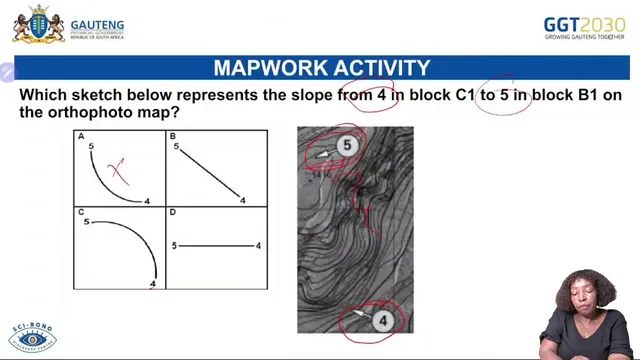
Finally, the lesson moves into impacts and preparedness. Environmental and social consequences of occluded and frontal systems include flooding, soil erosion, damage to biodiversity and vegetation, homelessness from wind damage, illness from contaminated water, electrical hazards, vehicle accidents, and costly government response. Precautionary strategies emphasize trimming tree branches, clearing loose materials, ensuring heating systems work, wearing warm clothing and boots, and limiting time outdoors during extreme cold and heavy rain. The latter part shifts to exam-style interpretation: identifying fronts and low-pressure centers on synoptic maps using isobars, recognizing cloud bands on satellite images, determining circulation direction (clockwise in the southern hemisphere), and using contour lines and map symbols for Grade 12 mapwork tasks.
Cornell Notes
Mid-latitude cyclones form between 30° and 60° latitude along the polar front where warm and cold air masses meet, producing a low-pressure system with both a cold front and a warm front. Students must recognize cyclone stages on synoptic maps: the mature stage shows clearly defined cold and warm fronts with a warm sector, while the occluded stage forms when the cold front catches the warm front due to denser cold air. Weather changes follow predictable patterns: cold fronts bring sharp temperature drops, pressure increases, wind shifts, and heavy rainfall along the cold front; warm fronts bring steadier precipitation with low layered clouds and more gradual temperature change. The lesson also links these systems to real impacts (flooding, erosion, wind damage, illness risk) and outlines practical preparedness steps like trimming trees and improving heating and clothing.
What exact conditions and location explain why mid-latitude cyclones form?
How can the mature stage be identified on a synoptic weather map?
What distinguishes an occluded stage, and how do warm-front vs cold-front occlusions differ?
What weather patterns typically occur with a cold front passing versus a warm front passing?
How do you identify mid-latitude cyclones on satellite imagery?
What preparedness actions are recommended for people facing mid-latitude cyclone conditions?
Review Questions
- On a synoptic weather map, what specific features let you distinguish the mature stage from the occluded stage?
- Describe the expected sequence of pressure, wind direction, temperature, and precipitation changes as a cold front passes.
- How would you use satellite cloud patterns and circulation direction to infer whether you’re viewing a southern-hemisphere mid-latitude cyclone?
Key Points
- 1
Mid-latitude cyclones form between 30° and 60° latitude along the polar front where warm and cold air masses meet, producing a low-pressure system with both cold and warm fronts.
- 2
The mature stage is marked by clearly defined cold and warm fronts, a warm sector, and a cold sector, with cold air advancing faster than warm air.
- 3
Occlusion occurs when the cold front catches the warm front due to denser cold air; identifying which front touches the surface at the base distinguishes warm-front occlusion from cold-front occlusion.
- 4
Cold fronts typically bring the heaviest rainfall along the cold front due to steep frontal lifting, followed by pressure rise, wind shift, and a sharp temperature drop.
- 5
Warm fronts tend to produce layered low clouds (stratus/nimbostratus) and steadier precipitation, with more gradual temperature change and different wind/pressure behavior.
- 6
Real-world impacts include flooding, soil erosion, wind damage (including fires and homelessness risks), electrical hazards, illness from contaminated water, and major costs for recovery.
- 7
Preparedness focuses on reducing hazards (trim trees, clear loose items), maintaining heating, dressing for extreme cold, and limiting time outdoors during heavy rain and strong winds.