America Always Gets This Wrong (when building transit)
Based on Not Just Bikes's video on YouTube. If you like this content, support the original creators by watching, liking and subscribing to their content.
Transit systems depend on walkable station areas filled with homes, jobs, and everyday destinations; without that, ridership stays low.
Briefing
North America’s public transit problem isn’t mainly about population size or whether rapid transit is “possible.” It’s about how cities are built: transit stations sit inside car-first land use patterns that leave riders with nowhere convenient to walk, shop, or live. Without dense, walkable destinations around stops, ridership stays low—and transit systems then struggle to win funding, service frequency, and public trust.
The transcript traces the pattern through familiar North American debates. When cities consider rail or tram projects, they often cite insufficient ridership to justify the investment, leading to downgrades from light rail to bus rapid transit and sometimes to nothing at all. The argument counters that claim with comparisons: smaller European cities run multiple tram lines and frequent rail service, while many Canadian and U.S. cities with larger populations still lack comparable rail networks. The deeper explanation offered is that North American development stopped being designed around transit decades ago.
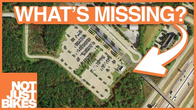
Historically, many North American towns grew along streetcar and rail corridors. Today, new growth is typically planned around roads and parking, with transit treated as an afterthought—an overlay on car-centric design. That approach produces “walk sheds” that are too small or too hostile: the area within a comfortable walking distance of a stop becomes dominated by parking lots, self-storage, empty lots, and wide arterial roads. Minimum parking requirements intensify the problem by forcing valuable near-station land to be used for cars rather than homes or destinations.
A Netherlands example is used to contrast outcomes. In a Dutch business park built around a train station and BRT line, buildings sit close to stops and wide sidewalks make walking direct. In Mississauga, Ontario, even impressive BRT stations drop riders beside high-speed roads, with long, unpleasant walks through seas of parking to reach nearby destinations. The claim is blunt: transit can be expensive and still underperform if the surrounding land use never becomes truly transit-supportive.
The transcript then connects this to transit-oriented development (TOD). TOD aims to upzone land near rapid transit so development can cluster where transit is convenient. But it often gets implemented too narrowly—upzoning only small strips near stations while surrounding areas remain single-family detached homes. The result is pressure to cram high-rise condos into limited parcels, creating towers next to low-density neighborhoods rather than the broader “missing middle” housing and walkable mixed-use fabric that makes transit feel practical.
A proposed fix is to plan for walkable mixed-use neighborhoods within a 10–15 minute walk of every rapid transit stop, not just a small upzoned zone. The transcript argues that transit and land use must be built together from the start; otherwise, car-oriented neighborhoods lock in driving habits and make later retrofits extremely difficult. Examples from Amsterdam and a “subway to nowhere” case in Chongqing illustrate the same principle: transit succeeds when development is allowed to grow around it, not after it.
Finally, the transcript suggests a pragmatic path for North America: revitalize older walkable areas built before the 1940s and connect them with frequent buses (around every 10 minutes) that can seed demand and expand into a larger rapid network over time. The overarching message is that transit won’t “work” as a band-aid for traffic; it works when cities build the destinations that make riding it the obvious choice.
Cornell Notes
Public transit underperforms in much of North America because stations are surrounded by car-first land use, not walkable destinations. The transcript argues that transit ridership depends on a “walk shed”—the area within a comfortable walking distance of stops—being filled with homes, jobs, and everyday services. Minimum parking rules and development patterns that prioritize parking lots and wide roads consume the most valuable near-station land, shrinking walkability and pushing people back into driving. Transit-oriented development often fails when upzoning is too limited, producing isolated towers rather than a connected mixed-use neighborhood. The remedy is to legalize and encourage walkable mixed-use development within roughly a 10–15 minute walk of rapid transit, and to connect existing pre-1940 walkable districts with frequent service to build momentum toward a broader network.
Why does the transcript say North America’s transit struggles are not mainly about city size or the feasibility of rapid transit?
What is the “walk shed,” and why is it treated as the most valuable land near transit?
How do parking requirements and station-area zoning contribute to low ridership?
What contrast is drawn between a Dutch station-area development and a Mississauga BRT stop?
Why does the transcript criticize many implementations of TOD?
What does the transcript propose as a practical strategy for cities that can’t easily build transit everywhere at once?
Review Questions
- How does the transcript connect station-area land use (parking, road design, and nearby destinations) to transit ridership outcomes?
- What specific TOD limitation is described, and how does it affect the type of housing and street-level experience near stations?
- Why does the transcript argue that building transit after car-oriented development is much harder than building transit alongside new mixed-use neighborhoods?
Key Points
- 1
Transit systems depend on walkable station areas filled with homes, jobs, and everyday destinations; without that, ridership stays low.
- 2
Minimum parking requirements and car-prioritizing zoning consume valuable near-station land that could support housing and services.
- 3
Treating transit as an overlay on car-centric planning produces long, unpleasant walks from stops to real destinations.
- 4
Transit-oriented development often underperforms when upzoning is too narrow, leading to isolated towers rather than connected mixed-use neighborhoods.
- 5
A workable standard proposed here is walkable mixed-use development within roughly a 10–15 minute walk of rapid transit stations.
- 6
Building transit alongside development is portrayed as essential; retrofitting car-dependent neighborhoods later is difficult because driving habits become entrenched.
- 7
Frequent bus service can connect existing walkable areas and help build momentum toward a broader rapid transit network.