Amsterdam Just Closed their Busiest Road
Based on Not Just Bikes's video on YouTube. If you like this content, support the original creators by watching, liking and subscribing to their content.
Amsterdam is running a six-week trial that blocks car through-traffic on Weesperstraat, a major road carrying about 27,000 vehicles daily through the city centre.
Briefing
Amsterdam has begun a six-week, partial shutdown of Weesperstraat—its busiest major road—by blocking car through-traffic with portable gates and temporary street narrowing. The move is designed to cut roughly 27,000 cars per day from the city centre, with the municipality studying knock-on effects on traffic flow, noise, and pollution during a tightly controlled trial (6 a.m. to 11 p.m.). While emergency vehicles can still pass, they are slowed by the gates; the tradeoff is fewer crashes and a quieter, safer street environment for residents.
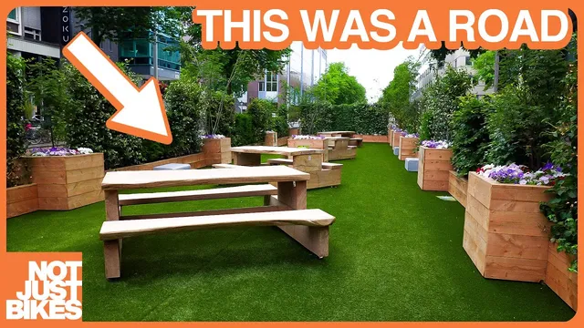
The project fits into a broader Dutch approach known as “knips” or “modal filters,” where walking and cycling remain possible but cars are prevented from driving through neighbourhoods. Amsterdam’s twist is scale and context: Weesperstraat is a road rather than a typical destination street, built in the 1960s during an era of American traffic-planning influence that prioritized moving motor vehicles and involved demolishing homes. For six weeks, the city is also using the physical design of the space—planters narrowing the roadway and a small pavilion with artificial grass and picnic tables—to make the current “car space” visible and to help residents imagine what a future redesign could look like.
The trial is explicitly temporary and data-driven. The city has published example concepts for what the road might become, but no permanent plan is announced yet. Still, the immediate impacts are already part of the political fight. Right-wing commentators and politicians quickly labeled the knip a “colossal failure,” often citing fears that drivers will detour, create congestion, and increase pollution. Those claims are met with skepticism: the shutdown targets through-traffic, not access—drivers can still reach local destinations by car, but north–south trips through the centre must use the highway instead.
A key argument in favor of the change is that Amsterdam has too many cars for the city it wants to be. The long-term goal is a nearly car-free Amsterdam, and the transcript contrasts the capacity of roads with alternatives: the subway runs directly under Weesperstraat and moves far more people than the road does, while trains and park-and-ride facilities (with parking at about €1 per day) offer ways for visitors and commuters to avoid driving into the centre. The underlying tension is framed as personal convenience versus public health, safety, and comfort—especially in areas where many households do not own cars.
Even so, the trial is not presented as painless. Cutting off parallel routes can push traffic onto nearby streets, and Kattenburgerstraat is one such monitored corridor where traffic reportedly increased during the morning rush. The response is to wait for official traffic counts rather than cancel the experiment after only a short period. The broader takeaway is that cities need time for drivers, travel habits, and navigation systems to adjust; if the quieter, cleaner, safer conditions persist, residents may come to prefer the new normal. The transcript also suggests that the loudest opposition may reflect fear that the policy will actually work.
Cornell Notes
Amsterdam launched a six-week trial blocking car through-traffic on Weesperstraat, a major north–south road that carries about 27,000 vehicles daily through the city centre. Portable gates and street narrowing reduce the road from two lanes to one and redirect drivers, while walking and cycling remain possible and emergency vehicles are still allowed. The municipality is studying traffic, noise, and pollution impacts from 6 a.m. to 11 p.m., with no permanent redesign decided yet, though future concepts have been published. The change is framed as part of the Dutch “knip” approach (modal filters) and as a step toward Amsterdam’s long-term goal of becoming nearly car-free. Critics predict detours and worse pollution, but the shutdown targets through-traffic rather than local access, and results are expected to clarify whether the fears hold up.
What exactly is being restricted on Weesperstraat, and how is the restriction enforced?
Why is Weesperstraat treated as a special case compared with typical Dutch knips?
How does the trial handle emergency vehicles and safety tradeoffs?
What are the main arguments used to defend the knip against claims of increased pollution and congestion?
What risks does the city acknowledge, and how is the project designed to address them?
Review Questions
- What does “knip” mean in practice, and how does it differ from closing a street entirely?
- How does the trial on Weesperstraat preserve local access while still reducing through-traffic?
- Which nearby street is mentioned as a place where traffic may increase, and why is that considered part of the monitoring plan?
Key Points
- 1
Amsterdam is running a six-week trial that blocks car through-traffic on Weesperstraat, a major road carrying about 27,000 vehicles daily through the city centre.
- 2
The restriction operates from 6 a.m. to 11 p.m. and uses portable barriers plus staff redirection, while also narrowing the roadway from two lanes to one with planters.
- 3
Walking and cycling remain possible under the knip approach, and emergency vehicles are always allowed through the gates.
- 4
The municipality is studying traffic, noise, and pollution impacts before deciding whether any redesign becomes permanent.
- 5
The trial targets through-traffic rather than access, so drivers can still reach local destinations but must use the highway for north–south trips through the centre.
- 6
Criticism focuses on detours, congestion, and pollution; the response is to wait for official before-and-after traffic counts and broader environmental data.
- 7
The long-term goal is a nearly car-free Amsterdam, supported by higher-capacity alternatives like the subway and park-and-ride for visitors and commuters.