How Much of the Earth Can You See at Once?
Based on Vsauce's video on YouTube. If you like this content, support the original creators by watching, liking and subscribing to their content.
Everest’s apparent dominance is mostly an artifact of scale: on a true-to-scale Earth model, its height shrinks to millimeters.
Briefing
Ever wondered why Earth looks so “big” from the ground but so “small” from space? The core answer is geometry: as your distance from a sphere increases, the amount of its surface you can see at once grows—but the portion you can fit into your field of view changes in a way that caps how much of the planet you can actually take in. That’s why Everest’s dramatic height all but vanishes when Earth is treated as a sphere, and why even astronauts on the International Space Station can only see a small slice of the world at any moment.
The transcript starts by scaling Everest against Earth’s diameter. If Earth is cut in half through Everest, the mountain’s prominence collapses into millimeters on a true-to-scale model—about 2 mm high on a 1T-diameter globe. The same idea corrects a common misconception created by diagrams: maps and cross-sections often stretch vertical exaggerations so strongly that Earth’s surface appears far rougher than it is. When the vertical and horizontal scales are matched, Earth’s “bumps” become tiny.
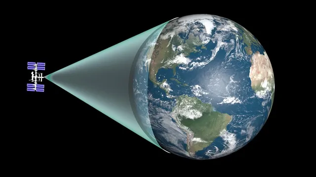
From there, the discussion shifts to what the eye can actually capture. For most people, the horizon limits visibility to a relatively small patch of Earth—roughly within about 80 square kilometers—because everything beyond the geometric horizon is hidden by curvature, with haze and refraction only slightly extending the range. The International Space Station improves the situation, but not as dramatically as intuition suggests: ISS residents see only about 3% of Earth at once, and even that slice is too wide to fit neatly into a window. Photographs taken from orbit can look like complete “disc Earths,” but lens distortion and framing compress what the eye would truly perceive.
The transcript then tackles a deeper question: how much of Earth’s matter is visible at all. Earth contains on the order of 10^50 atoms, yet only a thin surface layer is directly accessible to sight. A back-of-the-envelope estimate using atom-sized “circles” packed over a sphere yields about 1.5 × 10^34 atoms on the surface. But Earth isn’t smooth; its roughness adds extra surface area. Mathematicians model that roughness with a fractal dimension around 2.3, which boosts the estimate by roughly a thousand times—still leaving most atoms hidden beneath.
Next comes a reality check using famously flat terrain. Kansas is often called “flatter than a pancake,” and while it isn’t the flattest state by a topographical “flatness score,” it’s the one most commonly judged flat by people. Even so, the physical relief is tiny: a 130 mm pancake used in a 2003 study had height differences around 2 mm, and scaling that to Kansas implies mountain heights on the order of 10 km—comparable to Everest.
Finally, the transcript distinguishes “flatness” from “smoothness” and ties everything back to curvature. Earth is not a plane; it curves. Standing in Kansas, the far edges would appear about 8.1 km lower than the center, and the horizon acts like a visual cage whose radius depends on eye height. As distance increases, the visible fraction of Earth rises—up to half the planet at infinite distance—but in practice you can’t go far enough, and light levels fall so much that distant Earth would become effectively invisible. The result is a geometric, not mystical, explanation for why Earth’s full shape is so hard to see all at once—and why “smooth” still means “curved.”
Cornell Notes
Earth’s “at-once” visibility is governed by geometry: as you move away from a sphere, more of its surface becomes visible, but curvature and your field of view limit how much you can actually take in. Everest’s height shrinks to millimeters on a true-to-scale Earth, correcting the diagram-driven misconception that Earth is much rougher than it is. From the ground, the horizon restricts sight to a small patch (on the order of tens of square kilometers), while even the ISS shows only about 3% of Earth at once. Earth’s surface roughness can be modeled with a fractal dimension (~2.3), increasing the estimated number of visible atoms by about a thousand times—yet most atoms remain hidden beneath. The transcript also separates “flat” from “smooth”: Kansas can be extremely smooth, but it still curves with Earth, setting the horizon and the apparent drop-off across distance.
Why does Everest look enormous on maps but almost disappears when scaled correctly?
How does the horizon limit what you can see from Earth’s surface?
What fraction of Earth can astronauts on the International Space Station see at once, and why doesn’t it fill a window?
How many atoms on Earth’s surface are potentially visible, and how does roughness change the estimate?
Why is Kansas “pancake-flat” in feel, yet still not level across its width?
What sets the maximum fraction of Earth you could see at once, and why can’t you reach it?
Review Questions
- If Everest is only a few millimeters tall on a true-to-scale Earth model, what does that imply about the reliability of cross-section diagrams with mismatched axes?
- How do curvature and eye height combine to determine the horizon distance, and why can tall objects sometimes appear above the geometric horizon?
- Explain the difference between “flatness” (local relief) and “smoothness” (texture/roundness) using Kansas as an example.
Key Points
- 1
Everest’s apparent dominance is mostly an artifact of scale: on a true-to-scale Earth model, its height shrinks to millimeters.
- 2
The horizon is a geometric limit set by Earth’s curvature; for typical ground-level viewing it restricts visibility to a relatively small patch of surface area.
- 3
Even from orbit, the International Space Station sees only about 3% of Earth at once, and window framing plus lens effects can make photos look more complete than direct perception.
- 4
Earth’s visible matter is a thin surface layer: a simple atom-count estimate gives ~1.5 × 10^34 surface atoms, and fractal roughness (dimension ~2.3) can raise that by about a thousand times.
- 5
Kansas can be extremely smooth in local relief yet still curves with Earth, producing large apparent drops across long distances.
- 6
“Flat” and “smooth” are different: Earth is not a plane, and curvature—not just texture—controls what’s visible at once.
- 7
The theoretical maximum visible fraction of a sphere is half, but practical limits (distance and faint light) prevent reaching it in real viewing conditions.