How to Compare a Census with a Plat Map to Find your Ancestor's Home
Based on Roam Your Roots's video on YouTube. If you like this content, support the original creators by watching, liking and subscribing to their content.
A census entry without street names or house numbers can still be localized by matching neighboring households to property-owner names on a plat map.
Briefing
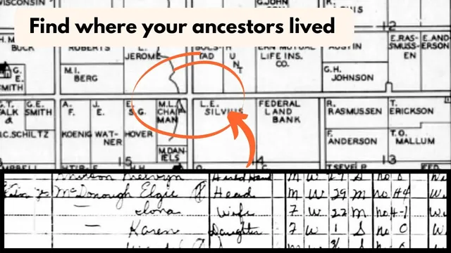
A missing street address in a 1940 census entry can be solved by cross-referencing nearby property owners on a plat map—turning vague “rented” household listings into a specific location. In this case, Elgie (spelled “algae” in the transcript) McDonough appears in the 1940 census with no street names or house numbers recorded by the enumerator, leaving no direct way to determine where he lived.
The census record also marks his home as rented (denoted by an “R”), which strongly limits follow-up options like deed or sale records tied to property ownership. With no address and no ownership trail, the search shifts to a 1942 plat map for Maple Grove Township in Barron County, Wisconsin. The key assumption is that Elgie and his family likely lived at the same place in 1942 as in 1940, even though the map is a couple of years later.
Plat maps list property owners, not renters. That means Elgie’s name won’t appear on the plat itself, but the neighbors who appear alongside him in the census should. The method relies on how census takers typically enumerated: the enumerator walked down the street and recorded households in order. On the census page, the neighbors listed immediately before and after Elgie become the anchor points.
The process begins by identifying the property owners on both sides of Elgie in the census. On one side, the census lists Louis Sylvius and Charles Macklin as nearby households. On the plat map, Sylvius Chapman appears, while Macklin does not; instead, another name farther away (L.B. Becker) shows up, and the researcher treats “L.B. Becker” as corresponding to “L.V. Becker” from the census transcription. By comparing which names appear earlier or later on the census pages, the researcher infers the direction the enumerator walked—suggesting a northward progression.
Next, the researcher checks the names after Elgie on the following census page. A key correction emerges: a person initially transcribed as “Frederick Cohn” is actually Frederick Jerome (the transcript notes an Ancestry transcription error). On the plat map, Frederick Jerome sits adjacent to Albert Wall. With Chapman/Sylvius on one side and Jerome/Wall on the other, the likely location for Elgie is narrowed to the property area between Chapman and Sylvius on one side and Jerome on the other—effectively placing him near an intersection.
By treating the census as an ordered walk and using the plat map’s property-owner boundaries, the researcher moves from an address-less “rented” census entry to a concrete placement on the Maple Grove Township plat map—showing how neighbor sequencing can bridge the gap when official identifiers are missing.
Cornell Notes
Elgie McDonough’s 1940 census entry lacks street names and house numbers, and his home is marked as rented, which blocks direct deed-based address hunting. A 1942 plat map for Maple Grove Township in Barron County, Wisconsin provides property-owner names but not renters. By assuming the census taker walked down the street and recorded households in order, the researcher uses the neighbors listed immediately before and after Elgie to identify the adjacent property owners on the plat. A transcription correction (Frederick Cohn → Frederick Jerome) further tightens the match. The result is a likely placement of Elgie’s rented home on the intersection area between the neighboring properties shown on the plat map.
Why does a “rented” marker in a census entry make address research harder, and what replaces that missing information?
How does the method use the order of names on the census to infer where the enumerator walked?
Why can’t Elgie’s name be found on the plat map, and how does that affect the search strategy?
What role does correcting a transcription error play in narrowing the location?
How does comparing neighbors on both sides of Elgie lead to a specific geographic placement?
Review Questions
- What assumptions must hold for a 1942 plat map to be used to locate a 1940 census household?
- How does the “order” of census neighbors function as a proxy for street addresses when house numbers are missing?
- Why is it important to verify transcription spellings (e.g., Frederick Cohn vs. Frederick Jerome) when matching census names to plat-map owners?
Key Points
- 1
A census entry without street names or house numbers can still be localized by matching neighboring households to property-owner names on a plat map.
- 2
A “rented” designation often prevents direct deed/sale research, making indirect methods like plat-map neighbor matching more valuable.
- 3
Plat maps typically list property owners, so renters must be inferred through adjacent neighbors rather than found by name.
- 4
Assuming the enumerator walked down the street, the sequence of names before and after a household can indicate walking direction and relative parcel placement.
- 5
Transcription errors can derail name matching; correcting them (such as Frederick Cohn to Frederick Jerome) can make the plat-map alignment work.
- 6
Using a later plat map (1942) requires a reasoned assumption that the household likely lived at the same location in the earlier census year (1940).