How Toronto Got Addicted to Cars
Based on Not Just Bikes's video on YouTube. If you like this content, support the original creators by watching, liking and subscribing to their content.
Toronto’s car dependence traces to post-1940s policy choices that removed streetcar capacity and expanded freeway infrastructure to prioritize motorists.
Briefing
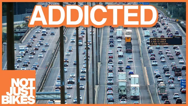
Toronto’s car addiction didn’t happen by accident—it was engineered through postwar freeway building, transit choices that prioritized motorists, and later political decisions that locked in suburban, low-density land use. The result is a city where the 401 carries the heaviest traffic in North America and where daily life is shaped by driving, even though Toronto once had a streetcar-based, walkable urban form.
The story starts with a city built for rail. Toronto grew along streetcar lines after streetcar service began in 1861, and its early transit infrastructure—like the first train station opening in 1858 and the later Union Station transition in 1927—supported dense, connected neighborhoods. That changed after the 1940s, when suburban development accelerated across North America and Toronto followed the same playbook: freeways designed for cars, subsidies and incentives for automobile ownership, and the removal of streetcar capacity to make room for motor traffic. Streetcar lines were torn out despite resistance, including a Parliament Street line removed in 1966 and a Mount Pleasant streetcar line where a 1976 business association poll found 88% of respondents wanted to keep it.
Transit expansion reinforced the same priorities. The Toronto subway opened in 1954 with explicit language about eliminating streetcar operations in downtown to free main streets for one-way traffic. Later reporting framed the subway as a congestion-relief project for the central city—again, tied to road space for drivers rather than transit riders. Even regional GO train service was structured around the reality that riders had to drive to stations, not rely on walkable access.
Freeways accelerated the shift. Neighborhoods were bulldozed for the Gardner Expressway, and the Don Valley Parkway’s route avoided some demolition largely because Hurricane Hazel struck in 1954. Major public protest slowed further damage, with Jane Jacobs playing a prominent role in stopping the Spadina Expressway, warning that planners were clinging to outdated technology and treating neighborhoods as “hardware.” Yet the damage was already done: Toronto’s former streetcar-connected urban fabric had been replaced in many areas by office blocks and surface parking, while postwar suburbs persisted as a “yellow belt” of single-family housing.
Politics then amplified the car-centric pattern. In 1998, Ontario’s conservative government forced the amalgamation of Toronto with surrounding municipalities despite referendums in all six areas voting to remain independent. The move was widely speculated to be political—shifting influence toward a fast-growing, largely left-leaning Toronto while absorbing conservative suburban voting power. That suburban dominance shaped city council outcomes, including the election of Rob Ford, who tore up bike lanes, canceled transit projects, and governed without consistent council approval. After Ford, details emerged about “unfinanced capital,” effectively undisclosed debt, underscoring how governance choices can compound long-term costs.
The core takeaway is that Toronto’s transit and land-use trajectory is inseparable from municipal politics. Car-first planning became self-reinforcing: low-density suburbs reduced transit viability, transit underinvestment increased car dependence, and electoral outcomes kept the system in place. Still, the city’s future may hinge on new transit projects nearing completion—an opening to reverse decades of car-centric planning and recover lost urban potential.
Cornell Notes
Toronto’s shift from streetcar-oriented growth to car dependence was driven by deliberate postwar decisions: streetcar lines were removed, subway and rail expansions were framed around freeing road space for motorists, and major freeways cut through neighborhoods. Public resistance—especially Jane Jacobs’ fight against the Spadina Expressway—slowed some destruction, but the underlying land-use pattern had already changed. The “yellow belt” of postwar single-family suburbs and underinvestment in transit locked in car dependence, making the 401 the busiest highway corridor. Political restructuring through the 1998 amalgamation helped suburban voting power dominate city decisions, contributing to setbacks like transit cancellations and bike-lane removals under Rob Ford. The result is a city whose transportation future is tightly bound to municipal elections and council control.
How did Toronto’s early urban form differ from the later car-dependent pattern?
What concrete transit decisions signaled that Toronto’s rapid transit was built for drivers more than riders?
Which streetcar removals and public reactions show that car-first changes faced resistance?
Why did freeways become a turning point, and how did disasters and protests affect what got built?
How did amalgamation and suburban political power reinforce car-centric planning?
What governance outcomes under Rob Ford connected transportation policy to broader fiscal consequences?
Review Questions
- What specific mechanisms—streetcar removal, subway goals, and freeway construction—combined to shift Toronto away from a rail-and-walk urban form?
- How did the 1998 amalgamation change the balance of political power, and why does that matter for transit and land-use decisions?
- Why does the transcript argue that municipal elections can determine whether a city can reverse car-dependent planning?
Key Points
- 1
Toronto’s car dependence traces to post-1940s policy choices that removed streetcar capacity and expanded freeway infrastructure to prioritize motorists.
- 2
The 1954 subway rollout was framed around eliminating downtown streetcar operations to free road space for one-way traffic.
- 3
Streetcar lines were cut even after public resistance, including a 1966 Parliament Street removal and a 1976 Mount Pleasant poll showing 88% support for keeping service.
- 4
Freeway building reshaped neighborhoods, with the Gardner Expressway involving bulldozing and the Don Valley Parkway benefiting from Hurricane Hazel’s 1954 disruption.
- 5
Jane Jacobs’ opposition helped stop the Spadina Expressway, but earlier damage to walkable, streetcar-connected urban form had already accumulated.
- 6
The 1998 amalgamation forced Toronto to absorb suburban municipalities despite pro-independence referendums, shifting council power and reinforcing car-centric outcomes.
- 7
Rob Ford’s tenure illustrates how transportation decisions, bike-lane removals, and transit cancellations can align with broader governance and fiscal practices that leave long-term debt.