I Visited the Best* City in North America (Montréal)
Based on Not Just Bikes's video on YouTube. If you like this content, support the original creators by watching, liking and subscribing to their content.
Montreal’s Metro combines high frequency with reliability, and some stations support cross-platform transfers that reduce transfer friction.
Briefing
Montreal’s transit and street design improvements are real—but the city’s car-first infrastructure still shapes daily life in ways that undercut the “best city in North America” hype. A week of riding the Metro and the new REM, walking pedestrianized streets, and cycling protected lanes shows a place that can build modern, human-scaled infrastructure quickly. Yet the same trip repeatedly runs into highways, car sewers, and transit gaps that make getting around outside the most improved neighborhoods feel slow, unsafe, or both.
On the transit side, Montreal’s Metro is frequent and extensive for Canada: four lines, 68 stations, and trains arriving about every two minutes in rush hour and every 3–10 minutes off peak. Some stations even support cross-platform transfers, and the system is notably reliable. A distinctive feature is rubber-tire trains—an approach tied to technology used in Paris—intended to deliver benefits like smoother operation; the ride isn’t dramatically quieter, but reliability is a standout. The biggest near-term upgrade is the REM, a new automated light-rail network designed to connect Montreal with surrounding cities. Most of the REM is planned to open in 2024 after the Eastern portion was canceled, and a small segment opened just before the visit, offering bright, spacious, driverless trains with platform screen doors and level boarding.
Cycling infrastructure is another major strength. Montreal has more than 900 km of bicycle lanes, much of it built in recent years, and the Plateau neighborhood stands out with protected routes and the blue-marked Réseau Express Vélo (REV) for longer-distance cycling. The city also uses “quick build” methods—temporary but robust solutions using materials like flexi sticks and temporary signals—when permanent construction isn’t politically or financially feasible. Still, the cycling network is uneven. Infrastructure quality varies sharply by borough, and the most dangerous roads often lack the protection cyclists need, forcing detours onto narrower streets with high vehicle speeds, frequent intersections, and compromises like bidirectional bike lanes that can become risky near driveways and cross streets.
The trip’s most persistent critique targets the city’s underlying car infrastructure and surface transit. Highways slice through the island, funneling traffic into “car sewers” and leaving many streets designed for through movement rather than local life. Montreal’s streetcar-era street network was dismantled decades ago, and buses—often stuck in traffic—struggle with slow schedules, long dwell times, and unreliable service. Even the Metro can dump riders onto inhospitable streets outside stations, including areas near major hubs where highways and parking lots dominate.
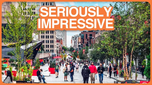
Pedestrianized streets and public space improvements provide the clearest “best-of” moments: dozens of blocks of summer car-free corridors, art, seating, and greenery, with cycling allowed while some other modes are restricted. But those wins are temporary and concentrated, while downtown and station access can feel hostile to pedestrians and cyclists. The overall conclusion is less “Montreal equals Europe” and more “Montreal has pockets of world-class urbanism”—especially when governance and political will align—surrounded by enough highway and transit shortcomings to limit how good the city feels day to day.
Cornell Notes
Montreal pairs fast, modern upgrades with stubborn car-first fundamentals. The Metro delivers frequent service and reliability, while the new REM adds automated, level-boarding, driverless light rail with safety features like platform screen doors. Cycling infrastructure is extensive—over 900 km of lanes—and the Plateau’s REV network shows how protected routes can support longer trips. Yet the cycling network is fractured across boroughs, and surface transit (buses in traffic) plus highway-driven street design make many trips outside the core slow or uncomfortable. The result is a city with several “walkable islands” and standout projects, but also highways, car sewers, and transit gaps that prevent the whole system from matching European-style consistency.
What makes Montreal’s Metro and REM stand out compared with typical North American transit?
Why does Montreal’s cycling success still feel inconsistent during day-to-day travel?
How do highways and street design shape the city’s “car sewer” problem?
What’s the critique of Montreal’s surface transit, and why does it matter for mobility?
Why does the transcript argue that Montreal’s pedestrianized streets can’t fully solve the city’s transport problems?
Review Questions
- Which Montreal transit features (Metro frequency, station transfers, REM design elements) most directly improve rider convenience and safety?
- How does borough-by-borough governance affect both cycling infrastructure quality and the consistency of safe routes?
- What specific transit and street-design factors make surface transit less effective as a connector between walkable neighborhoods?
Key Points
- 1
Montreal’s Metro combines high frequency with reliability, and some stations support cross-platform transfers that reduce transfer friction.
- 2
The REM is positioned as a major upgrade: automated, driverless light rail with platform screen doors and level boarding, with most of the network planned for 2024.
- 3
Cycling infrastructure is extensive (over 900 km), but route safety and quality vary sharply across boroughs, forcing detours and creating uneven user experiences.
- 4
Highways and “car sewer” street design still funnel large volumes of traffic into the city, shaping the environment around cycling and walking.
- 5
Surface transit—especially buses—can be slow and unreliable due to traffic delays and long dwell times, limiting its usefulness for short trips between walkable areas.
- 6
Summer pedestrianization delivers standout public space, but temporary implementation creates accessibility and design compromises and leaves much of the year car-focused.