Suburbs that don't Suck - Streetcar Suburbs (Riverdale, Toronto)
Based on Not Just Bikes's video on YouTube. If you like this content, support the original creators by watching, liking and subscribing to their content.
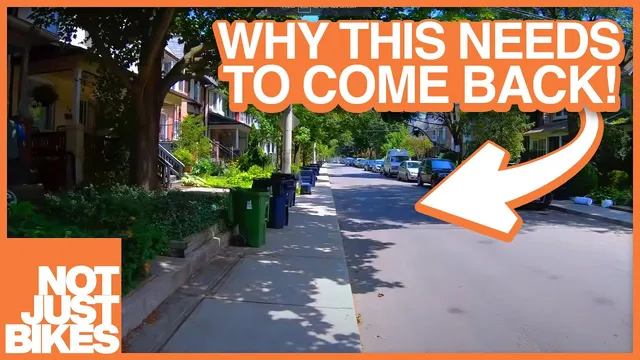
Riverdale is presented as a streetcar-suburb model where transit access, mixed uses, and human-scale streets enable daily life without constant car trips.
Briefing
Car-dependent suburbia isn’t a “suburbs vs. cities” choice—it’s a zoning-and-design outcome, and streetcar suburbs like Toronto’s Riverdale show what gets lost when car-first rules replace human-scale neighborhoods. Riverdale combines frequent transit access, mixed housing types, local shops, walkable streets, and parks that anchor daily life. The result feels family-friendly and community-oriented: narrow, tree-lined streets; kids able to walk to friends and school; grocery stores and cafés reachable without driving; and a street layout that keeps cars from dominating every trip.
Riverdale’s structure traces back to late-19th and early-20th century streetcar suburbs, which were built around streetcar lines and designed as self-contained, mixed-use areas. Even when streetcar tracks were later removed in many cities, the pattern left behind a street grid and neighborhood form that still supports walking and cycling. In Toronto, Riverdale’s streetcar infrastructure was partially converted into a subway in the 1960s, then later the removed streetcar line was gradually restored as a “stroad” was reworked back toward a street. That history matters because it illustrates how transportation policy can reshape the same geography into either a walkable neighborhood or a car-dependent landscape.
The transcript contrasts Riverdale’s walkability with modern car-dependent suburbia’s defining features: oversized roads, parking lots that dwarf shops, and strict separation between residential and commercial land uses that forces nearly every trip into a car. It also highlights how modern planning standards would reject Riverdale’s street form. A street that’s about six meters wide with street parking slows drivers and makes walking and cycling feel safer; modern traffic engineering would typically require much wider lanes (roughly 10–15 meters), which in turn demands more space for cars and reduces the ability to maintain a canopy and human-scale street edges.
Zoning rules are presented as the bigger barrier to building “another Riverdale.” The neighborhood’s fine grid and short, walkable routes would be replaced by winding streets and cul-de-sacs that increase block distances and make driving the rational choice. Mixed residential and commercial uses—common in streetcar suburbs—are largely prohibited by modern zoning maps that designate “houses only” areas. Schools, too, are often consolidated onto major arterials because children are assumed to require car trips, a self-fulfilling prophecy that undermines independent mobility.
Even housing variety is constrained: Riverdale’s mix of detached homes, apartments, townhomes, and co-ops would clash with rules favoring single-family-only development, minimum lot sizes, minimum building sizes, and limits on things like multiple front doors. Setbacks and parking minimums further standardize the look of suburbs and reduce density—front yards become mandatory, garages and cars become expected, and off-street parking requirements assume multiple vehicles per household.
Demand for walkable suburbs is described as real and measurable. Riverdale’s housing prices have outpaced the rest of the city for roughly 15 years, rising from about $170,000 in 1996 to around $1.2 million in 2021. Yet that success also creates scarcity: the transcript argues that even if people want neighborhoods like Riverdale, today’s regulations make it effectively impossible to build them at scale. The closing contrast points to the Netherlands, where regulations make car-dependent development harder, allowing suburbs that can remain quiet and financially viable without the traffic and design monotony of North American car-first planning.
Cornell Notes
Streetcar suburbs such as Toronto’s Riverdale demonstrate that “suburbs” can be walkable, mixed-use, and family-friendly when built around transit and human-scale streets. Riverdale’s design—narrow tree-lined streets, a fine grid, local shops and cafés inside the neighborhood, multiple housing types, and parks—supports daily life without constant car trips. Modern car-dependent suburbia differs sharply: wide roads, zoning that separates homes from commerce, school siting that assumes driving, and rules that enforce single-family sameness, large lots, setbacks, and parking minimums. Because those regulations effectively prevent the Riverdale pattern from being built today, demand pushes prices up and scarcity limits access. The transcript frames the problem as policy and design constraints, not an inherent flaw in suburbs themselves.
What makes Riverdale a “streetcar suburb,” and why does that matter for walkability?
How does Riverdale’s street design support pedestrians and cyclists compared with modern suburb streets?
Which zoning and planning rules are presented as the main reasons a Riverdale-like suburb can’t be built today?
How does Riverdale’s mix of housing types affect community and density?
Why does the transcript connect parking and lot design to neighborhood safety and aesthetics?
What does Riverdale’s housing price trend imply about demand and scarcity?
Review Questions
- List three specific design or zoning features that the transcript says enable Riverdale’s walkability.
- Explain how traffic engineering standards and road width requirements change pedestrian and cyclist comfort.
- What combination of land-use separation, housing restrictions, and parking minimums makes “another Riverdale” difficult to build today?
Key Points
- 1
Riverdale is presented as a streetcar-suburb model where transit access, mixed uses, and human-scale streets enable daily life without constant car trips.
- 2
Car-dependent suburbia is framed as a policy outcome—especially zoning—rather than an inherent problem with suburbs.
- 3
Narrow streets with street parking (about six meters in Riverdale) help slow traffic and make walking and cycling feel safer than modern wider-road standards.
- 4
Modern zoning typically separates homes from shops and cafés, consolidates schools onto arterials, and replaces fine street grids with cul-de-sacs that increase walking distances.
- 5
Housing variety is constrained by rules such as single-family-only zoning, minimum lot/building sizes, setback requirements, and even limits like “only one front door.”
- 6
Parking minimums and off-street space requirements assume multiple cars per household, reducing density and shaping the look of suburbs.
- 7
Riverdale’s rising housing prices (about $170,000 in 1996 to ~$1.2 million in 2021) are used to illustrate strong demand alongside regulatory scarcity.