Svalbard - The Northernmost Town on Earth
Based on Veritasium's video on YouTube. If you like this content, support the original creators by watching, liking and subscribing to their content.
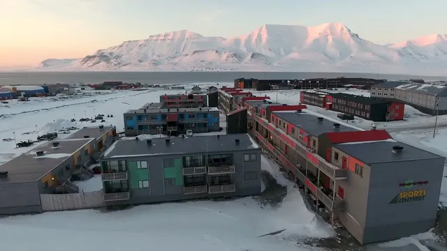
Longyearbyen sits at 78° north and is roughly 1,300 km from the North Pole, making it the northernmost real town on Earth.
Briefing
Longyearbyen on Norway’s Svalbard archipelago sits at 78° north—about 1,300 km from the North Pole—and functions as the northernmost “real town” on Earth, with more than 2,000 permanent residents. Life there is shaped by extreme geography and climate: only about 50 km of road exists, so residents rely heavily on snowmobiles (and there are reportedly more registered snowmobiles than people). Leaving town requires traveling with a gun and someone trained to use it, because polar bears roam the area. Daytime temperatures stay below freezing for all but four months, and for roughly four and a half months—from late October to mid-February—the sun never rises during the long polar night.
The settlement’s harsh present is matched by a difficult recent history. In December, an avalanche destroyed 10 homes and killed two people, underscoring how the landscape can turn deadly even within the town itself. Yet Svalbard’s story isn’t only about ice and survival. The hills around Longyearbyen contain rich coal deposits, mined for more than a century, and coal was once the engine that made the region livable. Coal was transported to the port using a network of aerial tramways—some of which still remain, even though they no longer operate.
Coal also points to a deeper timeline: Svalbard was not always an Arctic outpost. Roughly 360 million years ago, the archipelago lay near the tropics, just north of the equator. It was swampy and covered with large fern-like vegetation, reaching heights of about 10–30 meters. Over time, mud and sand buried the plants, and the area later submerged under the sea. Those layers eventually transformed into coal deposits, which later attracted miners from Norway, Russia, and the United States.
In the 20th century, mining brought people and infrastructure; now, most mines have closed and the economy is shifting toward tourism, education, and research. Visitors commonly travel by snowmobile and dog sled, while a university center offers semester courses in biology, physics, and geology. On a mountainside sits the Svalbard Global Seed Vault, a major research and preservation project. Local accounts also suggest growing international interest as the Arctic warms and sea-ice retreats, opening new northern trade routes. With Svalbard positioned between North America, Asia, and Europe, its strategic value may rise as the region becomes less cold and less remote. For now, Longyearbyen remains a stark example of how human ingenuity can sustain communities in places that seem almost designed to resist habitation.
Cornell Notes
Longyearbyen, Svalbard, sits at 78° north and is the northernmost real town on Earth, with over 2,000 residents. The town’s infrastructure is minimal—only about 50 km of road—so snowmobiles dominate daily travel, and polar-bear safety requires traveling with a gun and trained help. Extreme conditions include months of sub-freezing daytime temperatures and a long polar night when the sun doesn’t rise from late October to mid-February. The settlement exists largely because coal deposits were mined for over 100 years, a resource formed when Svalbard was once near the tropics and later became buried and transformed over hundreds of millions of years. As mining declines, the economy is shifting toward tourism, education, research, and international strategic relevance as Arctic ice shrinks.
Why does transportation in Longyearbyen rely so heavily on snowmobiles rather than cars or roads?
What makes personal safety in Longyearbyen unusually demanding?
How do seasonal light and temperature shape life in Svalbard?
How did coal mining make Svalbard’s settlement possible, and what infrastructure supported it?
What geological history explains why Svalbard has coal at all?
What economic shift is underway in Svalbard, and why might its strategic importance grow?
Review Questions
- How do limited roads and polar-bear risk together shape daily life and travel choices in Longyearbyen?
- What chain of events—both environmental and geological—connects Svalbard’s tropical past to its modern coal economy?
- What factors suggest Svalbard’s role could change as Arctic ice shrinks, and how does that relate to its location between major regions?
Key Points
- 1
Longyearbyen sits at 78° north and is roughly 1,300 km from the North Pole, making it the northernmost real town on Earth.
- 2
With only about 50 km of road, residents rely mainly on snowmobiles, to the point that registered snowmobiles outnumber residents.
- 3
Polar-bear safety is built into travel rules: departures require a gun and someone trained to use it.
- 4
Extreme conditions include sub-freezing daytime highs for most of the year and a long polar night from late October to mid-February.
- 5
Coal mining—supported by aerial tramways—was the main driver of habitation for over a century, but most mines have now closed.
- 6
Svalbard’s coal formed after a tropical-era swamp was buried and submerged hundreds of millions of years ago, turning vegetation into coal.
- 7
As Arctic ice shrinks, Svalbard’s strategic position between North America, Asia, and Europe may increase, while the economy shifts toward tourism, education, and research.