The Best-Designed Town in the Netherlands (and therefore, the world)
Based on Not Just Bikes's video on YouTube. If you like this content, support the original creators by watching, liking and subscribing to their content.
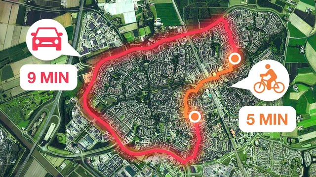
Houten’s cycling advantage comes from routing cars to longer ring-road paths while keeping internal destinations direct by foot and bike.
Briefing
Houten (Hton) has become a global reference point for how to build a “nearly car-free” town where cycling is faster than driving for most trips—and where that choice reshapes everyday life, especially for families. The core design move is blunt: destinations inside the town are quick to reach on foot or by bike, while cars are pushed to the outside ring road and forced onto longer routes. The result is a modal reality—about 70% of trips within the town are by bicycle—so car volumes stay low across most neighborhoods, making streets feel safe, calm, and active rather than congested or hostile.
The town’s layout reinforces that philosophy at every scale. Houten was established in the early 1800s, but its major growth came from expansion plans in the 1970s; today it has over 50,000 residents, with most development built in the last few decades. From above, Houten looks like two circular districts—an original ring-based area built in the 1980s and a second expansion added in the early 2000s—connected by a figure-eight ring road that carries through traffic around the neighborhoods. Each circle has a train station near its center, giving the town two stations despite its size, and the station exits are designed to funnel people toward cycling infrastructure immediately.
Cycling safety and speed are treated as engineering priorities, not marketing. The network relies on linear parks and treeline bicycle “highways” that connect neighborhoods without forcing frequent interactions with cars. At crossings with motor traffic, cyclists often go under roads, and at intersections cyclists receive priority so they rarely need to stop. Traffic lights are largely absent for cyclists, and modal filters block through car movement—drivers can access local streets but cannot use them as shortcuts, which keeps car speeds and volumes low. Even shared streets work because the design limits who can drive there and how often.
Housing and public space are built to match the mobility system. Row homes and front doors open directly onto bicycle paths or shared open spaces, while car parking is pushed to the back or into smaller lots accessed by separate service streets. The town also mixes housing types—single-family homes, apartments, and townhouses—an approach linked to the “missing middle” problem in North America, where zoning often prevents diverse housing. For children, the payoff is independence: kids can cycle to school and friends without constant adult escort, with examples including child carriers for younger children and independent cycling for older ones.
Houten isn’t presented as flawless. Bus service is constrained by the ring road, with stops spaced far apart and some routes running only every 30 minutes, and the area around the Castellum station feels less inviting than the main station. The most serious irritation is mopeds allowed on bicycle paths; Amsterdam restricted mopeds on many bike routes in 2019, but Houten still faces fast micro-mobility conflicts, prompting calls for speed enforcement.
The broader takeaway is policy-oriented: cars are a reality, but motor-vehicle access must be restricted so high-density living can remain human-scaled. With density inside the ring road above 5,000 people per square kilometer, Houten demonstrates that suburban growth can be both dense and livable—if cities build transit and cycling first, then design car routes to be the exception rather than the default.
Cornell Notes
Houten (Hton) is held up as a model for “nearly car-free” town design, where cycling is typically faster and more convenient than driving. The key planning choice is to keep internal trips easy by bike and walking while forcing cars to use longer routes via an outer ring road. That approach produces low car volumes, which makes bicycle streets and shared spaces work safely, including intersections with cyclist priority and grade-separated crossings. The town also pairs mobility with housing and public space—homes often face bicycle paths, car parking sits behind buildings, and a mix of housing types supports residents through different life stages. The result is a family-friendly environment with high child independence, though bus frequency and moped speed on bike paths remain problems.
What single design principle makes cycling outperform driving inside Houten?
How does Houten’s ring-road layout protect neighborhoods from motor traffic?
What infrastructure details make cycling both fast and safe in practice?
How does Houten’s housing design reinforce the cycling-first street network?
Why does the town’s housing mix matter beyond transportation?
What problems still undermine the “perfect cycling town” ideal?
Review Questions
- Which planning mechanism forces most car trips to become longer than bike trips in Houten?
- Name two specific design features that reduce cyclist stops at intersections.
- How do modal filters and parking placement work together to keep car traffic from dominating local streets?
Key Points
- 1
Houten’s cycling advantage comes from routing cars to longer ring-road paths while keeping internal destinations direct by foot and bike.
- 2
Low car volumes (about 70% of internal trips by bicycle) make bicycle streets and shared spaces function safely.
- 3
The town’s two circular districts—built in the 1980s and early 2000s—use a ring-road “shield” to keep through motor traffic out of neighborhoods.
- 4
Cycling speed and safety are engineered through cyclist priority at crossings, minimal traffic lights for bikes, and grade-separated movements under major roads.
- 5
Housing fronts often face bicycle paths, while car parking is pushed to the back or into smaller lots accessed separately, supporting child independence.
- 6
Transit gaps remain: bus routes and stop spacing are constrained by ring-road operations, and service frequency can be low.
- 7
Moped access to bicycle paths creates conflicts; stronger restrictions or speed enforcement is presented as necessary.