The Most Dangerous Places to Cycle in Amsterdam
Based on Not Just Bikes's video on YouTube. If you like this content, support the original creators by watching, liking and subscribing to their content.
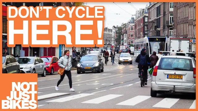
Amsterdam’s most hazardous cycling conditions concentrate on major corridors where cyclists are routed into narrow painted space or mixed traffic rather than fully protected lanes.
Briefing
Amsterdam’s cycling reputation holds up in many places, but the city’s most dangerous riding conditions concentrate where car traffic is mixed into the street design—especially on major shopping and ring roads where cyclists are funneled into narrow painted gutters or cramped separations. The result is a recurring pattern: when bicycle infrastructure isn’t wide enough for demand or isn’t physically protected from turning vehicles, delivery traffic, and tram movements, cyclists end up weaving through conflicts that feel avoidable.
A key distinction runs through the rundown: some areas are merely uncomfortable because they’re crowded, while others are genuinely risky because the street layout forces cyclists into close proximity with cars, vans, and trams. Suburbs outside the core are largely left out because they tend to have wide cycle paths and protected intersections—an outcome of space being available in car-era planning. In contrast, several central corridors create friction even when bike lanes exist. Kinkerstraat is cited as narrow and constrained by columns and parked bicycles, though the opposite direction improves after a car lane is removed. Overtoom and similar routes benefit from protected bicycle paths that would impress many countries, yet they still struggle when sidewalks and curbside parking overflow into bike space.
The most serious problems show up on busy streets where Amsterdam’s approach to speed limits can leave cyclists without dedicated infrastructure. On “Javastraat,” a dense shopping street with constant parking maneuvers and delivery vans, traffic is mixed because 30 km/h streets don’t automatically require bicycle facilities. The proposed fix is structural: pedestrianize the street to reclaim space for shoppers and allow deliveries without private vehicle traffic, or convert it to one-way for motor vehicles to reduce conflict.
Other high-risk areas include parts of the S100 ring road (Statsoutersgata), where some segments have narrow separated paths but others dump cyclists into painted gutters beside angled parking. Near Vondelpark, the cycle path becomes too narrow as car lanes widen for turning, and red markers separating bike and sidewalk can still leave cyclists nearly stuck during peak tourist season. The same “wrong place” warning repeats on streets like Nasokata, where cyclists are effectively routed into high-speed car environments; locals are described as using an adjacent street (Marnekstra) that restricts through car traffic, making cycling calmer—except at the next bottleneck.
Rosencraft is flagged as an intersection where too many modes collide: cars, bicycles, and tram lines turning in different directions. Farther east, Rosencrach is described as a major driver route out of the city center with no protected infrastructure, increasing car volumes and amplifying the danger of parked cars and mixed traffic. Streets such as Van Volstrad and Xylstrad—both tied to major routes and tram presence—are characterized as busy, crowded, and sometimes physically squeezing cyclists between parked vehicles and tram tracks.
The broader takeaway is that Amsterdam is a “work in progress.” Even where modern design standards exist, older infrastructure can persist for decades, and advocacy groups have historically fought to prevent regressions. The lesson offered is practical: cities can’t be redesigned overnight, so the quality of bicycle infrastructure standards—and the political will to enforce them—determines whether today’s improvements last or get replaced by painted lines and renewed conflicts years later.
Cornell Notes
Amsterdam’s worst cycling conditions cluster where street design mixes cyclists with high-volume car, delivery, and tram movements—often forcing riders into narrow painted gutters or cramped separations. The rundown distinguishes uncomfortable congestion (crowding, overflow, narrow paths) from true danger caused by mixed traffic layouts, turning vehicles, and tram intersections. Several major shopping and ring-road corridors are highlighted as especially problematic because cyclists are routed into environments where speed-limit rules don’t guarantee bicycle infrastructure. The contrast with calmer local streets and car-restricted routes underscores that traffic volume and physical separation matter more than the city’s overall cycling reputation. The closing message frames Amsterdam as a long-term improvement project, with older infrastructure sometimes lingering for decades unless advocacy and redesign cycles push change.
Why are Amsterdam’s suburbs portrayed as comparatively safe for cycling?
What makes Kinkerstraat uncomfortable, and why isn’t it labeled the most dangerous?
How does the street design on Javastraat create risk for cyclists?
What’s the recurring problem pattern on the S100 ring road and near Vondelpark?
Why is Rosencraft singled out as especially hazardous?
What does the “work in progress” conclusion add to the argument about Amsterdam’s cycling safety?
Review Questions
- Which factors distinguish “uncomfortable” cycling from “dangerous” cycling in the Amsterdam examples given?
- Why does the 30 km/h rule matter for bicycle infrastructure on streets like Javastraat?
- How do traffic restrictions on nearby streets (like the contrast between Nasokata and Marnekstra) change the cycling experience?
Key Points
- 1
Amsterdam’s most hazardous cycling conditions concentrate on major corridors where cyclists are routed into narrow painted space or mixed traffic rather than fully protected lanes.
- 2
Suburbs are comparatively comfortable because they tend to have wide cycle paths and protected intersections built with more physical room.
- 3
Crowding can make rides unpleasant (overflow onto bike space), but the highest risk comes from design choices that place cyclists near turning cars, delivery vehicles, and tram movements.
- 4
On Javastraat, mixed traffic is intensified by parking maneuvers and delivery traffic, and bicycle infrastructure is limited by the 30 km/h street rule.
- 5
Parts of the S100 ring road and areas near Vondelpark can become nearly impassable during peak tourist periods when bike space is too narrow.
- 6
Intersection design is a major safety determinant: Rosencraft combines cars, bicycles, and tram turning movements in a single conflict-heavy junction.
- 7
Amsterdam’s cycling network improves over time, but older infrastructure can persist for decades unless advocacy and redesign cycles push upgrades.