The "Mountain Or Valley?" Illusion
Based on minutephysics's video on YouTube. If you like this content, support the original creators by watching, liking and subscribing to their content.
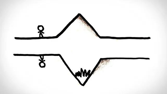
Shaded relief illusions hinge on how the brain interprets shadow position as a cue for 3D shape.
Briefing
Shaded relief maps and aerial photos can make the same terrain look like it’s either “popping out” or “cut in,” and the flip often comes down to a simple lighting mismatch. When shadows fall on the bottom of a feature, the brain tends to read it as convex—like a bump rising toward you. When shadows fall on the top, the brain tends to read it as concave—like a dent receding away. That rule feels reliable because, on Earth, the sun is effectively always overhead, so shadows usually land beneath objects.
The illusion becomes multistable because nature has a symmetry that can trick perception. A concave surface lit from one side can cast shadows that closely resemble the shadows from a convex surface lit from the opposite side. In other words, “bump vs. dent” isn’t determined by the geometry alone; it’s inferred largely from where the shadows sit. A bump lit from above produces shadows on its bottom. A dent lit from below can also produce shadows on its bottom—so the same shadow pattern can correspond to opposite shapes. The same logic applies at landscape scale: a mountain range lit from the east casts shadows on its western slopes, while a valley lit from the west can also cast shadows on its western slopes.
From ground level, context usually resolves the ambiguity. From high altitude—where the viewer lacks cues like nearby objects, scale references, or personal movement—the brain leans heavily on shadow placement. That’s why geographic features can appear to switch between “mountain” and “valley” interpretations when the map is viewed upside down or when the assumed light direction doesn’t match the actual one.
Cartography often bakes this bias into the product. Shaded relief maps commonly use a convention where light is treated as coming from a fixed direction (notably, the northern hemisphere maps often assume light from the north), even though the sun doesn’t shine from that direction in most locations. The tradeoff is intentional: mapmakers prioritize consistent visual communication of terrain over strict physical accuracy of sun position.
The practical takeaway is straightforward: if a terrain map looks wrong, rotate it 180 degrees. A quick mental flip can swap the perceived convex/concave interpretation and make valleys and mountains line up with what the landscape actually is. The same perceptual quirk that turns the duck/rabbit illusion into a moment of confusion can also make Mars plateaus look like either raised landforms or canyon-cut depressions—depending on how the shadows are interpreted.
Cornell Notes
Shaded relief maps can make the same terrain appear either raised (“mountain”) or carved (“valley”) because the brain uses shadow position as a cue for 3D shape. On Earth, the sun is effectively overhead, so shadows usually fall on the bottoms of objects, reinforcing the “shadows on bottom = convex” rule. But concave and convex features can produce similar shadow patterns when lit from opposite sides, creating a multistable perception. From high altitude, where context is limited, viewers rely more on shadows alone, so rotating a map can flip the interpretation. Cartographers sometimes choose a fixed lighting convention (even when physically inaccurate) to keep terrain communication consistent.
Why do shaded relief maps often make bumps look like bumps and dents look like dents?
How can concave terrain be mistaken for convex terrain (and vice versa)?
Why does the illusion get worse when looking from far above?
What role do mapmaking conventions play in the illusion?
What simple action can help if a terrain map looks upside down or confusing?
Review Questions
- When shadows appear on the bottom of a shaded feature, what shape does the brain most likely infer, and why?
- Describe the shadow-based symmetry that allows concave and convex features to look similar under different lighting directions.
- Why might a northern-hemisphere shaded relief map look “wrong” even if the terrain is accurate?
Key Points
- 1
Shaded relief illusions hinge on how the brain interprets shadow position as a cue for 3D shape.
- 2
On Earth, the sun’s overhead geometry trains a strong expectation that shadows fall beneath objects.
- 3
Shadows on the bottom of a feature typically bias perception toward convex “bump” shapes, while shadows on the top bias toward concave “dent” shapes.
- 4
Concave and convex forms can cast similar shadow patterns when lit from opposite sides, enabling multistable perception.
- 5
From high altitude, limited contextual cues make shadow placement the dominant information source, increasing the likelihood of flipping interpretations.
- 6
Cartographic lighting conventions (like assuming light from a fixed direction) can be physically inaccurate but improve consistent terrain readability.
- 7
Rotating a confusing map 180° often corrects the perceived “mountain vs valley” direction by aligning the implied light with the viewer’s expectations.