The North Pole is Moving And We Don’t Know Why
Based on Sabine Hossenfelder's video on YouTube. If you like this content, support the original creators by watching, liking and subscribing to their content.
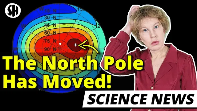
Earth’s geographic north pole is fixed to the rotation axis, but magnetic north moves because the magnetic field evolves.
Briefing
Earth’s magnetic north pole has been moving much faster than in the past, and scientists still can’t say exactly why or where it’s headed next. The geographic north pole—tied to Earth’s rotation axis—stays fixed, but the magnetic pole that drives compass directions and navigation is shifting rapidly enough to force frequent updates to widely used models. That matters because modern navigation depends on the magnetic field, and even small directional errors can compound into large real-world mistakes for aircraft, ships, and drilling operations.
For roughly 400 years, the magnetic north pole drifted slowly around northern Canada at about 5 to 10 km per year. In the late 1990s, its pace accelerated sharply: by the early 2000s it was moving toward Siberia at up to around 50 km per year. The practical consequence is that systems relying on magnetic north can’t treat it as a stable reference point. Instead, they depend on the World Magnetic Model, a database maintained by the US National Geospatial-Intelligence Agency and the British Geological Survey. Militaries, commercial airlines, shipping, satellite systems, and oil and gas companies all use it.
Oil and gas firms care because drilling direction depends on accurate angles. A fraction-of-a-degree error can translate into a significant offset over long distances underground, so operators track changes in the magnetic field rather than assuming it stays constant. Historically, the World Magnetic Model was updated every five years, but in 2019 researchers issued an out-of-cycle update because the magnetic field was drifting too quickly for the older model to remain acceptably accurate. More recent updates have also introduced higher-resolution options, reflecting how quickly the underlying field is changing.
The north pole’s motion is only part of a broader magnetic trend. Over the past two centuries, the overall strength of Earth’s magnetic field has declined by roughly 10%. In addition, the South Atlantic Anomaly—a region of unusually weak magnetic field—has been a persistent feature where charged particles can penetrate deeper into the atmosphere, affecting satellites and other systems.
At the center of the mystery is the geodynamo: Earth’s magnetic field is generated in the outer core, about 2,000 km beneath the surface, by the motion of molten, electrically conducting iron and nickel. Those flows create electric currents, which in turn produce magnetic fields. Researchers can’t directly observe the core’s turbulent fluid motion, so they infer it from surface magnetic measurements and related data such as gravity and earthquake observations. Current reconstructions suggest two major “bundles” of magnetic field regions—one under Canada and one under Siberia—where the Canadian region has weakened while the Siberian one has strengthened, pushing the overall magnetic north toward Siberia.
Scientists still don’t know what will happen next. A major concern is a possible magnetic reversal, when the magnetic poles swap. Earth has reversed hundreds of times in the past, and the Sun’s magnetic cycle flips every 11 years, but there’s no clear sign that Earth’s field is about to reverse. Even so, the uncertainty is heightened by limited historical measurements—there’s no complete long-term record comparable to what exists for recent centuries. The most likely near-term reality is continued drift, with navigation and modeling needing to keep up as the magnetic reference point keeps moving.
Cornell Notes
Earth has two “norths”: a geographic north fixed to Earth’s rotation axis, and a magnetic north tied to Earth’s magnetic field. The magnetic north pole has accelerated dramatically since the late 1990s, moving toward Siberia at up to about 50 km per year, forcing frequent updates to navigation models. The World Magnetic Model—maintained by the US National Geospatial-Intelligence Agency and the British Geological Survey—feeds systems used by militaries, airlines, satellites, and oil and gas drilling. The best explanation points to changes in the outer-core geodynamo, where molten iron and nickel generate the field, but the detailed cause remains unclear. A magnetic reversal is a known historical possibility, yet there’s currently no evidence it’s imminent.
Why does “north” change for navigation even though the geographic north pole doesn’t move?
What timeline and speed changes characterize the magnetic north pole’s recent movement?
How do magnetic-field changes affect drilling and other industrial operations?
What is the World Magnetic Model, and why did it need an out-of-cycle update in 2019?
What does the geodynamo have to do with the moving magnetic poles?
What are scientists most worried about regarding Earth’s magnetic field, and is a reversal expected soon?
Review Questions
- How does the movement of magnetic north differ from the stability of geographic north, and what practical systems rely on each?
- What evidence supports the idea of two competing magnetic regions under Canada and Siberia, and how does that relate to the pole’s direction of travel?
- Why can’t scientists directly observe the geodynamo, and what types of measurements are used instead to infer changes in Earth’s magnetic field?
Key Points
- 1
Earth’s geographic north pole is fixed to the rotation axis, but magnetic north moves because the magnetic field evolves.
- 2
The magnetic north pole accelerated from about 5–10 km per year to roughly 50 km per year toward Siberia in the early 2000s.
- 3
Navigation and industrial systems rely on updated magnetic models because small directional errors can compound into large real-world offsets.
- 4
The World Magnetic Model—maintained by the US National Geospatial-Intelligence Agency and the British Geological Survey—required an out-of-cycle update in 2019 due to faster-than-expected drift.
- 5
Earth’s magnetic field strength has declined by about 10% over the past two centuries, alongside regional anomalies like the South Atlantic Anomaly.
- 6
The geodynamo in the outer core generates the field, but its turbulent flow can’t be directly observed, so scientists infer it from surface magnetic, gravity, and earthquake-related data.
- 7
A magnetic reversal is a known historical possibility, but there’s currently no sign it’s imminent.