They Tore Down a Highway and Made it a River (and traffic got better)
Based on Not Just Bikes's video on YouTube. If you like this content, support the original creators by watching, liking and subscribing to their content.
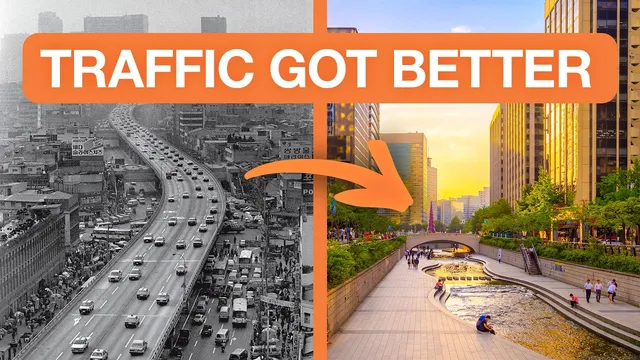
Seoul demolished the Cheonggyecheon elevated expressway and converted the corridor into a stream-and-linear-park destination rather than rebuilding road capacity.
Briefing
Seoul’s decision to demolish a central elevated highway and replace it with the Cheonggyecheon stream corridor delivered a rare double win: traffic improved without travel-time penalties, and the city gained a major public space that cut pollution and revitalized downtown. The project is widely cited as “traffic evaporation”—the idea that removing road capacity can reduce driving demand rather than trigger gridlock—and Seoul’s results helped silence years of warnings from media, special interests, and traffic models.
After the Cheonggyecheon expressway was removed, motor vehicle traffic fell by 45% within three years. Metro ridership rose 3%, bus ridership climbed 15%, and drivers did not face longer travel times. Those outcomes validated decades of urban-planning research, but the project’s impact went beyond congestion metrics. The highway’s removal was paired with a transformation of the corridor into a linear park and waterway that drew people back to the city center—more walking, new business activity after years of decline, and renewed residential and commercial development.
The benefits were measurable in environmental and public-health terms as well. Nitrogen dioxide levels dropped 35%, and average summer temperatures on nearby streets fell by about 3.5 degrees. Noise pollution declined too. Wildlife also returned: fish and bird populations increased significantly after the expressway was gone. The corridor became a top tourist destination, with features designed to make the walk itself engaging—outdoor libraries, seating areas, historic elements such as a renovated stone bridge, and varied landscaping that shifts from more engineered beginnings near the fountain toward a more natural look downstream.
A key part of the story is that the project treated the former highway space as an opportunity to rebuild urban life, not just manage stormwater. The stream corridor includes water-management infrastructure intended to handle extreme rainfall, with floodgates that can drain surrounding street runoff into the channel during heavy storms. During the narrator’s visit, the system was active during a rain event: stairs were closed and flow increased, but the area did not flood.
Still, the transformation wasn’t perfect. The stream sits below street level, which can make access feel disconnected from surrounding neighborhoods. Entry often relies on stairs, with limited wheelchair access via long ramps and gaps between accessible points. The design trade-off appears tied to maintaining flood safety.
Seoul’s success with Cheonggyecheon also helped unlock further car-reduction projects, including Seoullo 7017—an elevated roadway converted into a pedestrian walkway near Seoul Station. While smaller in scale than the stream, it similarly tames traffic, adds shade and plantings, and includes amenities like rest stops, a café, water features, and public art. The walkway’s main shortcoming is transit connectivity: nearby BRT and metro access can require detours across busy roads or through parking areas.
Taken together, the Cheonggyecheon and Seoullo 7017 cases argue for a broader principle: urban highways don’t belong in city centers because they divide neighborhoods, degrade liveability, and pollute the local environment—yet they also fail to deliver lasting congestion relief. Seoul’s approach shows that removing car infrastructure can improve mobility while creating destinations that people actually want to use.
Cornell Notes
Seoul replaced the Cheonggyecheon elevated expressway with a stream-and-park corridor and saw traffic improve rather than collapse. Within three years of removal, motor vehicle traffic dropped 45%, metro ridership rose 3%, bus ridership increased 15%, and drivers reported no increase in travel time. The project also reduced nitrogen dioxide by 35% and lowered summer temperatures by about 3.5 degrees, alongside major cuts in noise pollution. Downtown life returned: more walking, business activity rebound, new development, and increased wildlife. A key limitation is access—because the corridor sits below street level, many entries rely on stairs and wheelchair-friendly routes are limited, likely constrained by flood-management requirements.
What is “traffic evaporation,” and how did Seoul’s highway removal test it?
Which outcomes went beyond congestion to show broader urban benefits?
How did the Cheonggyecheon design handle flooding risk?
What trade-offs did the project make for accessibility and neighborhood connection?
How does Seoullo 7017 extend the same idea in a different form?
Why does the transcript emphasize that the “least interesting aspect” isn’t traffic?
Review Questions
- What specific before-and-after numbers from Seoul support the claim that removing the expressway improved mobility?
- Which environmental indicators improved after Cheonggyecheon’s conversion, and what mechanisms in the design helped manage flood risk?
- How do Cheonggyecheon and Seoullo 7017 differ in scale and accessibility challenges, and what common principle links them?
Key Points
- 1
Seoul demolished the Cheonggyecheon elevated expressway and converted the corridor into a stream-and-linear-park destination rather than rebuilding road capacity.
- 2
Within three years, motor vehicle traffic dropped 45% while metro ridership rose 3% and bus ridership rose 15%, with no increase in travel time for drivers.
- 3
The project reduced nitrogen dioxide by 35% and lowered average summer temperatures by about 3.5 degrees on neighboring streets, alongside major noise reductions.
- 4
Downtown life rebounded after years of decline: more walking, business activity growth, and new residential and commercial development.
- 5
Cheonggyecheon’s water-management system is designed for extreme rainfall (200-year flood events) using floodgates to drain runoff into the corridor.
- 6
Accessibility remains a weak point because the stream sits below street level, making stair-based entry common and limiting wheelchair-friendly routes.
- 7
Seoullo 7017 shows the same car-removal-to-destination approach on a smaller scale, though transit connections (BRT/metro) are less direct than they could be.