What is Sea Level?
Based on minutephysics's video on YouTube. If you like this content, support the original creators by watching, liking and subscribing to their content.
Sea level is defined using gravity, not as a simple average of ocean surface height.
Briefing
Sea level isn’t a single “ocean average” number—it’s a carefully defined reference tied to gravity, and it has to account for Earth’s shape, uneven mass, and the gravitational pull of land. That’s why a height like “Mt. Everest is 8850 m above sea level” can be meaningful even though there’s no ocean beneath it for hundreds of kilometers.
A simple approach works only in idealized worlds. If Earth were flat, sea level would just be the average ocean height. If Earth were a perfect sphere, sea level could be defined as a constant distance from Earth’s center. Real Earth is neither: it spins, so centrifugal effects push material outward near the equator and slightly squash the poles. The result is a planet about 42 km wider at the equator than from pole to pole. Under that spherical assumption, the ocean surface at the equator would sit roughly 21 km above sea level defined at the north pole—showing that geometry alone already forces a more nuanced definition.
Even an ellipsoidal model still falls short because Earth’s interior isn’t uniform. Density varies from place to place, which makes gravity slightly stronger or weaker across the globe. Oceans respond to that uneven gravitational field by “puddling” more near denser regions. The consequence is large enough to matter: sea level can differ by as much as 100 m from what a smooth, uniform ellipsoid would predict.
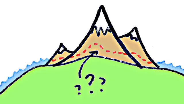
Land adds another complication. Continents are dense rock masses that protrude from the ellipsoid and tug extra water toward themselves, raising sea level nearby. Ocean-floor valleys have less mass, so water tends to flow away from them, lowering local sea level. This creates the core conundrum for mountain measurements: a mountain’s presence changes the nearby gravitational field, so the sea level “around” it depends on whether the reference should include the mountain’s mass or exclude it.
Geodesists resolved this by defining sea level in terms of gravity rather than direct ocean height. They built an extremely detailed model of Earth’s gravitational field—called the Earth Gravitational Model—and used it to establish a consistent sea-level reference surface. Modern GPS receivers incorporate this model so altitude readings don’t drift by tens of meters due to regional gravity differences; the model enables geodesists to predict the average ocean level to within about a meter worldwide. With that framework, “sea level under mountains” is computed as it would be if the mountains weren’t there geometrically, but their gravitational influence were still included—making Everest-style elevations comparable across the planet.
Cornell Notes
Sea level can’t be defined as a simple average ocean height because Earth’s rotation and gravity vary by location. Spinning makes Earth wider at the equator and squashed at the poles, so an ellipsoidal shape is needed even before considering gravity. Uneven density inside Earth changes local gravity, causing oceans to “puddle” and shift sea level by up to ~100 m compared with a uniform model. Continents further distort sea level by their mass, raising water near land and lowering it near low-mass regions. Geodesists therefore define sea level using gravity via the Earth Gravitational Model, which is also built into GPS to keep altitude references consistent worldwide.
Why does Earth’s rotation force a different sea-level reference than a simple “average ocean height”?
How can local gravity differences change sea level by amounts as large as 100 m?
What role do continents play in determining sea level near mountains?
Why is defining “sea level under a mountain” tricky?
How does the Earth Gravitational Model make sea level consistent enough for GPS and mountain elevations?
Review Questions
- If Earth were perfectly spherical and not rotating, what would sea level correspond to geometrically, and why does that fail for the real Earth?
- Explain how variations in Earth’s internal density lead to ocean “puddling” and measurable sea-level differences.
- Why does the gravitational influence of a mountain matter when converting its height into “meters above sea level”?
Key Points
- 1
Sea level is defined using gravity, not as a simple average of ocean surface height.
- 2
Earth’s rotation makes it an ellipsoid, with the equator about 42 km wider than the pole-to-pole distance.
- 3
Non-uniform density inside Earth changes local gravity, shifting sea level by up to roughly 100 m compared with a uniform model.
- 4
Continents raise nearby sea level through their gravitational pull, while low-mass seafloor regions lower it.
- 5
Mountains complicate “height above sea level” because their mass alters the gravitational field that shapes the reference surface.
- 6
The Earth Gravitational Model provides a consistent gravity-based sea-level reference and is used in modern GPS to prevent large altitude errors.
- 7
Geodesists use the gravity-based definition to compute what sea level would be under mountains if the mountains weren’t there geometrically, but their gravity were still included.