Why Google Maps Fails in Amsterdam
Based on Not Just Bikes's video on YouTube. If you like this content, support the original creators by watching, liking and subscribing to their content.
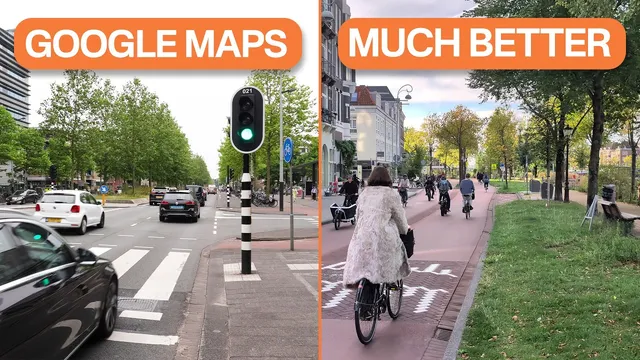
Google Maps’ cycling routing in Amsterdam often fails because its algorithms are built around car-centric US assumptions rather than Dutch bicycle-priority route networks.
Briefing
Google Maps often routes cyclists in Amsterdam onto car-dominated streets because its navigation logic is built around American driving assumptions—so it misses the Netherlands’ core design strategy: separate car traffic from bikes not just with lanes, but with different route networks. The result is directions that may still get a rider to the destination, yet frequently choose the least enjoyable and least safe-feeling path for cycling.
The mismatch starts with how US cities are typically planned. In many North American street networks, cars are allowed almost everywhere, and traffic engineering often treats the street grid as a way to keep cars moving even when individual roads get blocked or congested. That mindset feeds directly into navigation apps: real-time rerouting is optimized for shaving minutes for drivers, and “faster” usually means using arterial roads. Cycling in that environment becomes an accommodation problem—riders must fit into a system designed to move as many vehicles as possible.
Amsterdam flips the priorities. Dutch cities aim to move people efficiently while protecting livability: streets are managed to reduce noise, pollution, danger, and space consumption from cars. A key tool is the “hoofdnet” (main network) for through car traffic, with “plusnet” roads prioritizing cars. Crucially, cycling has its own prioritized network with minimal overlap with car plusnets. Safety comes from “ontvlechten” (unbundling/disentangling): driving routes and cycling routes are designed to be fundamentally separate, so cyclists are likely to encounter far less motor-vehicle traffic.
Google Maps doesn’t understand that separation. It generates bike directions using algorithms that assume cyclists will follow routes similar to cars, even when Amsterdam offers better bicycle-optimized paths. The transcript highlights several practical failures: one-way street rules are often not correctly represented for cycling, and routes tend to return riders to major roads quickly—where bike lanes exist—rather than using quieter residential streets that usually require fewer stops.
The comfort-and-safety logic also diverges. In the US and Canada, protected bike lanes often signal the “least dangerous” option because many streets are genuinely hazardous. Google Maps appears to treat those lanes as a universal safety proxy. In Amsterdam, however, once riders leave the major roads, car traffic is already low and streets are designed to keep speeds down (including a city-wide default of 30 km/h and reduced parking). That means protected lanes can be unnecessary or even worse—narrow lanes can become crowded and slow.
Beyond cycling, the transcript argues Google Maps carries a broader car-centric bias in how it visually represents neighborhoods. Streets that are pedestrian-heavy and not meant for through driving can appear smaller or nearly invisible, while car-oriented corridors are emphasized. The piece also criticizes travel-time estimates: Google may use historical data to predict transit and walking times, but not similarly realistic driving factors like parking availability or taxi wait times. In a city where driving into the center is often a poor choice, those optimistic estimates can steer people toward cars, contributing to weekend traffic lines.
The takeaway is not that Google Maps is useless, but that it can be actively misleading in a human-scale city. For Amsterdam cycling, the transcript points to Dutch-specific route planning tools—especially Fietsersbond’s route options and junction-based knooppunten networks—as examples of routing that treats cycling as a distinct mobility experience with different priorities than driving.
Cornell Notes
Amsterdam’s cycling directions often fail because Google Maps is optimized for car networks and American driving assumptions. Dutch cities prioritize livability and safety by separating car and bike routes through systems like hoofdnet/plusnet and “ontvlechten,” which keeps cyclists away from motor-vehicle traffic. Google Maps largely ignores those route networks, misreads cycling access on one-way streets, and tends to push riders onto major roads with bike lanes—sometimes the least comfortable option in a city where car traffic is already reduced. The transcript also argues Google Maps’ broader mapping and time estimates skew toward driving by emphasizing car-relevant street importance and using overly optimistic assumptions for parking and taxi waits. For better results, Dutch tools like Fietsersbond and knooppunten planners align routing with cycling-specific goals.
Why does Google Maps’ cycling routing often feel wrong in Amsterdam even when it still reaches the destination?
How do Dutch street networks reduce car-bike conflict compared with typical North American approaches?
What specific routing behaviors does the transcript criticize in Google Maps for Amsterdam cycling?
Why might “protected bike lanes” lead to worse routes in Amsterdam than in the US or Canada?
What is a modal filter, and how does it affect routing and neighborhood life?
How does the transcript argue Google Maps can mislead drivers in Amsterdam?
Review Questions
- What planning concept in Dutch cities (“ontvlechten”) changes the relationship between car routes and bike routes, and why does that break Google Maps’ assumptions?
- List two reasons the transcript gives for why protected bike lanes can be a less optimal choice in Amsterdam than in North America.
- How do modal filters differ from winding street designs as a strategy to reduce through traffic, and what does that mean for cyclists?
Key Points
- 1
Google Maps’ cycling routing in Amsterdam often fails because its algorithms are built around car-centric US assumptions rather than Dutch bicycle-priority route networks.
- 2
Dutch cities separate car and bike movement through “ontvlechten,” meaning cyclists often ride on routes with far less motor-vehicle traffic by design.
- 3
Amsterdam’s hoofdnet/plusnet system routes through car traffic away from neighborhoods, while cycling has its own prioritized network with minimal overlap for safety.
- 4
Google Maps can mis-handle cycling access on one-way streets and tends to steer cyclists back onto major roads with bike lanes, even when residential routes are quieter and require fewer stops.
- 5
Protected bike lanes are treated as a safety proxy by Google Maps, but in Amsterdam they can be unnecessary or less comfortable due to low car volumes and lane crowding.
- 6
The transcript argues Google Maps’ neighborhood visualization and travel-time estimates can be car-biased, underestimating driving friction like parking search and taxi wait times.
- 7
For Amsterdam cycling, Dutch-specific tools such as Fietsersbond route planning and knooppunten junction networks better match cycling priorities like fewer stops, scenic comfort, and car-restricted routing.